Table of Contents
Mount Cika is located in the south-west of Albania. It is positioned on the seashore, between the Ionian Sea (to the west) and the Shushica Valley (to the east). The port city of Vlora is 40 km north-west of Çika.
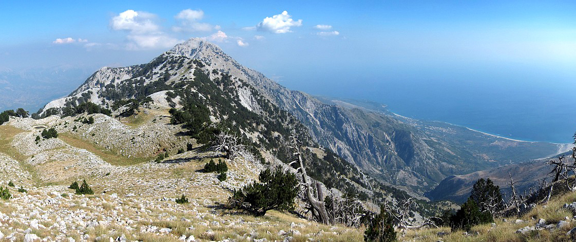
Mount Cika looks like the roof of the entire Ionian Riviera. It divides the sea from the valleys of the country’s southern highlands. Mount Çika splendidly rises 2045 meters above sea level. It is one of the highest peaks in Albania. The mountain looks very high also because it starts straight from the sea level. Its range starts at the Karaburun peninsula, and as it’s running south it’s becoming taller and taller.
This mountain range runs almost for the whole length of the Ionian coast until the city of Sarande.
Mount Çika is at 85th place in Europe’s highest mountain peaks. The northern part of Cika is part of Llogara National Park. On the peaks of Cika mountain, there is a magnificent view of the northern Ionian Islands. As well as the Italian coast of Apulia (including Otranto). At the end of the western side of the mountain, there are small beaches. They attract tourists during the summer months. These beaches include Himarë, Palasa, Dhermi, and Jala.
Mount Çika slopes
Mount Çika western slope is inextricable by a large tectonic detachment. From it, several blocks of limestone have slid over one another. They caused this slope to fall gradually over the Ionian Sea. So, this is how the Himara Rivierais formed. Himara is the most picturesque part of the entire Albanian Riviera.
The eastern slope is softer and falls over the Shushica valley. Today’s relief forms are very rough, with sharp peaks and very steep slopes. It is this site that is used for climbing and snowboarding.
The northern slope of Cika is recognized by the International Union. It is known for the Conservation of Nature because it is a biologically rich and diverse area. Mount Çika is also the peak of the Ceraunian (or Acroceraunian) Range.
Childe Harold’s Pilgrimage
This mountain is included in Lord Byron’s epic poem “Childe Harold’s Pilgrimage”. Its range stretches along almost the entire length of the Ionian coast until it reaches the southernmost city of Saranda. Its grandeur continues to intrigue to this day. Besides, it remains one of the most challenging and in-demand spots for avid climbers, explorers, skiers, and mountaineers. Included in many tourist itineraries of this region, Çika is ideal for hiking and advanced climbing. This is because of its wonderful climate, and the breathtaking landscape.
Some verses from Childe Harold’s Pilgrimage:
“Here roams the wolf, the eagle whets his beak,
Birds, beasts of prey, and wilder men appear,
And gathering storms around convulse the closing year.”
Rock Formations
The western slope of Mount Çika is created by rock separations. The separations were caused by tectonic movements. As a result, gigantic rock formations have seemingly fallen on top of one another. If you see it from above, it looks like the mountain forms a staircase. Then it leads all the way down to the shores of the Ionian Sea. The part that cannot be seen from the sea is very steep, descends over the valleys of the Shushica highlands. It is known for its deep and steep chasms.
Landscape and Panoramas
The scenery you see when climbing Mount Çika is truly incredible and unforgettable. The panorama reveals a vast expanse that includes three other remote sites; The Karaburun Peninsula, Sazan Island, and the Greek island of Corfu. It’s not an easy climb, so get prepared physically and mentally. It may tire you out, but the panoramas at the peak will make you forget all about the grueling hike. Also, you will appreciate the sheer beauty of Albanian nature’s endless gifts. As mentioned before, you’ll see the gorgeous beaches of Himara, Palasa, Dhërmi, and Jala, side by side.
Mountaineers and Shepherds
Mount Çika is a known spot where professional mountaineers from all over Europe meet. But, these rugged slopes, are the first and foremost refuge of local shepherds. According to them, the wild vegetation of the southern ridge is the most suitable sustenance for cattle. Once you see them grazing there, you’ll understand the high-quality dairy produced from such pastures!
Well, if you at this part of the article I dare say that you love hiking. If so, here are some trail maps:
Trail running / Llogara Pass – Mount Cika
The path starts near Panorama restaurant. The trail is technically not difficult but long and tiring. Count a minimum of 4 hours to reach the top. The views are absolutely stunning therefore, they make up for the hard work. If you are not willing to go all the way, stop after the first climbing part. It is around 2.5mi from the start. You can find some shade there while enjoying the view. Because of the weather, it is better to start early.

0 Comment